

Just as the first birds are beginning to filter south from northern regions of North America, BirdCast is beginning its live 24-hour monitoring of bird migration across the continental United States by using impressive weather radar technology to provide birders with an exciting opportunity to literally watch bird migration live. In addition, BirdCast provides some interesting assessments of the previous night's migration details, including the timing, flight elevations, and species composition of migrating birds – county by county, state by state, across the Lower 48 States – plus there are bird migration forecasts and alerts!
Whether you check on bird migration periodically, twice a week, or daily, it is always interesting to see how migration is progressing through the season. This August there has been migration action right from the start of the initial days of BirdCast operation, which resumed last Saturday, August 1st. Keep in mind that most birds migrate at night, and you will quickly see how migration activities increase after sunset and taper down toward sunrise. There are 4 topic-based webpages for you to access anytime at no charge, including Live Maps, Future Maps, the Migration Dashboard, and the Migration Alerts webpage.
To give you an example of a method to bird migration monitoring, many birders like to start with a look at the Live Maps webpage, to see what is happening at that moment, as well as how migration progressed overnight. You can also access any previous days' information for a few years back during fall and spring migrations. The active radar image of the Live Map is pretty self-explanatory, so jump right in and see what has been happening on during the past 24 or 48 hours at Live Maps – BirdCast
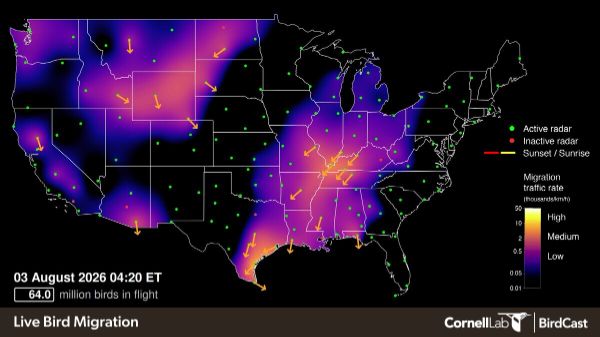
Next, it's a good plan to support the Live Map activity with a look at Your Local Migration Dashboard, which permits you to check migration progress in above your county or state. The Dashboard provides a variety of information including the estimated number of birds in flight hour by hour, with a total overnight estivate, the altitude of migrating birds hour by hour, the direction the birds were flying, and a photo list of birds likely to be migrating during that period as indicated by eBird records. Access the Migration Dashboard at Your Local Migration Dashboard – BirdCast
Migration Forecast Maps add an interesting twist to monitoring bird migration by providing migration forecasts 3 nights into the future on radar-simulated maps, providing information similar to weather forecasts. The 3 maps are updated every 6 hours, so you can plan ahead with some level of confidence. However, it is important to keep in mind that the Migration Maps show birds in flight that may continue migrating past any given location where you hope to find more birds. To learn more and view the maps, see Forecast Maps – BirdCast
The fourth BirdCast option you can take advantage of is the Migration Alerts page, in which you simply type the name of a city within the Lower 48 States, and you will see Migration Alerts labeled Low, Medium, or High for the next 3 nights. You can also sign up for optional Alerts that are delivered to your email account. Learn more at Migration Alerts – BirdCast
You can access all 4 BirdCast webpages most easily at Discover Bird Migration – BirdCast, and be sure to enjoy and use the bird migration information to your advantage as you enjoy birding and learning more about birds through the coming months. BirdCast is provided by The Cornell Lab of Ornithology and associated staff from contributing universities.